We have been applying SLIM in Indonesia for more than 10 years. Our first main application was the Mahakam river-lake-delta system. The Mahakam is a 980-km-long tropical river in the East Kalimantan province (Borneo Island) that flows into the Makassar Strait through a complex delta. We used SLIM2D to simulate the hydrodynamics of the Makassar Strait, the Mahakam Delta and the three lakes upstream of the delta. The hydrodynamics of the rivers, from the upstream limit of the delta to the lakes and further upstream, were simulated with SLIM1D. The model has been thoroughly validated with in-situ water elevation, flow velocity, and water discharge observations. The hydrodynamic model outputs were then used to simulate sediment transport and water age through the river-lake-delta system.
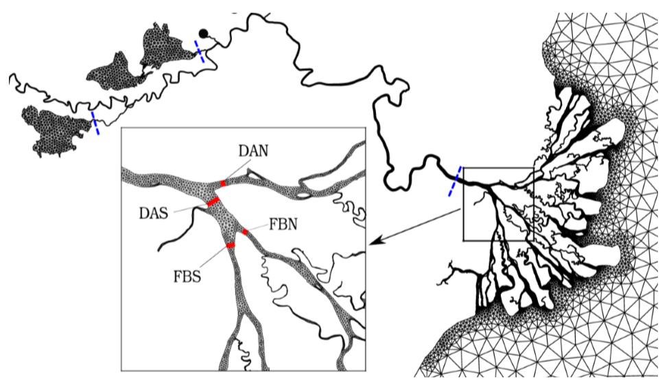
Overview of the unstructured mesh discretization of the Mahakam river-lake-delta-sea system. Another area of application of SLIM in Indonesia is the Kapuas river delta, located in the western part of Borneo Island. The Kapuas is a 1140-km-long river that flows into the Karimata Strait. We studied the hydrodynamics of the Kapuas Kecil branch that merges with the Landak river in the city of Pontianak. We were particularly interested in assessing the compound flooding risk in the river delta and in the city of Pontianak arising from the interplay between storm surges, tides and the river discharge. We considered a model setup that included the floodplains in the river delta as well as the entire city of Pontianak to simulate the inundation dynamics. This model setup was subsequently used to train a machine learning algorithm to reduce the computational cost of flooding predictions.
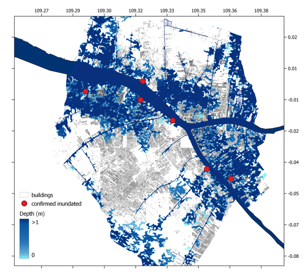
Simulated inundation map in the city of Pontaniak during the flood event on 29 December 2018 at 06:00 UTC. Finally, we are currently applying SLIM to the Wakatobi National Park (WNP), in the Coral Triangle, to estimate coral connectivity and identify reefs best suited for conservation and restoration projects. We assessed the interannual and interspecific variability of different connectivity indicators and identified sub-reefs that were consistently ranked high for all eight years and for both species. We found that both El Niño and La Niña events lead to a significant increase in larval exchanges across the WNP for both species. Overall, our results suggest that, under the current WNP zoning, there is limited overlap between marine protected zones and the reefs identified as best candidates for reef protection and restoration based on larval connectivity.
External collaborators
Prof. Ton Hoitink (Wageningen University), Prof. Jamaluddin Jompa (Hasanuddin Universtiy) and Dr Joko Sampurno (Universitas Tanjungpura)
To learn more…
778265
indonesia
1
apa
50
date
desc
4823
https://www.slim-ocean.be/wp-content/plugins/zotpress/
%7B%22status%22%3A%22success%22%2C%22updateneeded%22%3Afalse%2C%22instance%22%3Afalse%2C%22meta%22%3A%7B%22request_last%22%3A0%2C%22request_next%22%3A0%2C%22used_cache%22%3Atrue%7D%2C%22data%22%3A%5B%7B%22key%22%3A%22MW6CBVLC%22%2C%22library%22%3A%7B%22id%22%3A778265%7D%2C%22meta%22%3A%7B%22lastModifiedByUser%22%3A%7B%22id%22%3A6462585%2C%22username%22%3A%22MiguelDLC%22%2C%22name%22%3A%22%22%2C%22links%22%3A%7B%22alternate%22%3A%7B%22href%22%3A%22https%3A%5C%2F%5C%2Fwww.zotero.org%5C%2Fmigueldlc%22%2C%22type%22%3A%22text%5C%2Fhtml%22%7D%7D%7D%2C%22creatorSummary%22%3A%22Faryuni%20et%20al.%22%2C%22parsedDate%22%3A%222024%22%2C%22numChildren%22%3A1%7D%2C%22bib%22%3A%22%26lt%3Bdiv%20class%3D%26quot%3Bcsl-bib-body%26quot%3B%20style%3D%26quot%3Bline-height%3A%202%3B%20padding-left%3A%201em%3B%20text-indent%3A-1em%3B%26quot%3B%26gt%3B%5Cn%20%20%26lt%3Bdiv%20class%3D%26quot%3Bcsl-entry%26quot%3B%26gt%3BFaryuni%2C%20I.%20D.%2C%20Saint-Amand%2C%20A.%2C%20Dobbelaere%2C%20T.%2C%20Umar%2C%20W.%2C%20Jompa%2C%20J.%2C%20Moore%2C%20A.%20M.%2C%20%26amp%3B%20Hanert%2C%20E.%20%282024%29.%20Assessing%20coral%20reef%20conservation%20planning%20in%20Wakatobi%20National%20Park%20%28Indonesia%29%20from%20larval%20connectivity%20networks.%20%26lt%3Bi%26gt%3BCoral%20Reefs%26lt%3B%5C%2Fi%26gt%3B%2C%20%26lt%3Bi%26gt%3B43%26lt%3B%5C%2Fi%26gt%3B%281%29%2C%2019%26%23x2013%3B33.%20%26lt%3Ba%20class%3D%26%23039%3Bzp-DOIURL%26%23039%3B%20href%3D%26%23039%3Bhttps%3A%5C%2F%5C%2Fdoi.org%5C%2F10.1007%5C%2Fs00338-023-02443-y%26%23039%3B%26gt%3Bhttps%3A%5C%2F%5C%2Fdoi.org%5C%2F10.1007%5C%2Fs00338-023-02443-y%26lt%3B%5C%2Fa%26gt%3B%26lt%3B%5C%2Fdiv%26gt%3B%5Cn%26lt%3B%5C%2Fdiv%26gt%3B%22%2C%22data%22%3A%7B%22itemType%22%3A%22journalArticle%22%2C%22title%22%3A%22Assessing%20coral%20reef%20conservation%20planning%20in%20Wakatobi%20National%20Park%20%28Indonesia%29%20from%20larval%20connectivity%20networks%22%2C%22creators%22%3A%5B%7B%22creatorType%22%3A%22author%22%2C%22firstName%22%3A%22Irfana%20Diah%22%2C%22lastName%22%3A%22Faryuni%22%7D%2C%7B%22creatorType%22%3A%22author%22%2C%22firstName%22%3A%22Antoine%22%2C%22lastName%22%3A%22Saint-Amand%22%7D%2C%7B%22creatorType%22%3A%22author%22%2C%22firstName%22%3A%22Thomas%22%2C%22lastName%22%3A%22Dobbelaere%22%7D%2C%7B%22creatorType%22%3A%22author%22%2C%22firstName%22%3A%22Widyastuti%22%2C%22lastName%22%3A%22Umar%22%7D%2C%7B%22creatorType%22%3A%22author%22%2C%22firstName%22%3A%22Jamaluddin%22%2C%22lastName%22%3A%22Jompa%22%7D%2C%7B%22creatorType%22%3A%22author%22%2C%22firstName%22%3A%22Abigail%20Mary%22%2C%22lastName%22%3A%22Moore%22%7D%2C%7B%22creatorType%22%3A%22author%22%2C%22firstName%22%3A%22Emmanuel%22%2C%22lastName%22%3A%22Hanert%22%7D%5D%2C%22abstractNote%22%3A%22%22%2C%22date%22%3A%2202%5C%2F2024%22%2C%22section%22%3A%22%22%2C%22partNumber%22%3A%22%22%2C%22partTitle%22%3A%22%22%2C%22DOI%22%3A%2210.1007%5C%2Fs00338-023-02443-y%22%2C%22citationKey%22%3A%22faryuniAssessingCoralReef2024%22%2C%22url%22%3A%22https%3A%5C%2F%5C%2Flink.springer.com%5C%2F10.1007%5C%2Fs00338-023-02443-y%22%2C%22PMID%22%3A%22%22%2C%22PMCID%22%3A%22%22%2C%22ISSN%22%3A%220722-4028%2C%201432-0975%22%2C%22language%22%3A%22en%22%2C%22collections%22%3A%5B%22GJSQZPDC%22%5D%2C%22dateModified%22%3A%222026-02-16T13%3A06%3A05Z%22%7D%7D%2C%7B%22key%22%3A%22M6RKKS6A%22%2C%22library%22%3A%7B%22id%22%3A778265%7D%2C%22meta%22%3A%7B%22lastModifiedByUser%22%3A%7B%22id%22%3A6462585%2C%22username%22%3A%22MiguelDLC%22%2C%22name%22%3A%22%22%2C%22links%22%3A%7B%22alternate%22%3A%7B%22href%22%3A%22https%3A%5C%2F%5C%2Fwww.zotero.org%5C%2Fmigueldlc%22%2C%22type%22%3A%22text%5C%2Fhtml%22%7D%7D%7D%2C%22creatorSummary%22%3A%22Sampurno%20et%20al.%22%2C%22parsedDate%22%3A%222023-01-01%22%2C%22numChildren%22%3A1%7D%2C%22bib%22%3A%22%26lt%3Bdiv%20class%3D%26quot%3Bcsl-bib-body%26quot%3B%20style%3D%26quot%3Bline-height%3A%202%3B%20padding-left%3A%201em%3B%20text-indent%3A-1em%3B%26quot%3B%26gt%3B%5Cn%20%20%26lt%3Bdiv%20class%3D%26quot%3Bcsl-entry%26quot%3B%26gt%3BSampurno%2C%20J.%2C%20Ardianto%2C%20R.%2C%20%26amp%3B%20Hanert%2C%20E.%20%282023%29.%20Integrated%20machine%20learning%20and%20GIS-based%20bathtub%20models%20to%20assess%20the%20future%20flood%20risk%20in%20the%20Kapuas%20River%20Delta%2C%20Indonesia.%20%26lt%3Bi%26gt%3BJournal%20of%20Hydroinformatics%26lt%3B%5C%2Fi%26gt%3B%2C%20%26lt%3Bi%26gt%3B25%26lt%3B%5C%2Fi%26gt%3B%281%29%2C%20113%26%23x2013%3B125.%20%26lt%3Ba%20class%3D%26%23039%3Bzp-DOIURL%26%23039%3B%20href%3D%26%23039%3Bhttps%3A%5C%2F%5C%2Fdoi.org%5C%2F10.2166%5C%2Fhydro.2022.106%26%23039%3B%26gt%3Bhttps%3A%5C%2F%5C%2Fdoi.org%5C%2F10.2166%5C%2Fhydro.2022.106%26lt%3B%5C%2Fa%26gt%3B%26lt%3B%5C%2Fdiv%26gt%3B%5Cn%26lt%3B%5C%2Fdiv%26gt%3B%22%2C%22data%22%3A%7B%22itemType%22%3A%22journalArticle%22%2C%22title%22%3A%22Integrated%20machine%20learning%20and%20GIS-based%20bathtub%20models%20to%20assess%20the%20future%20flood%20risk%20in%20the%20Kapuas%20River%20Delta%2C%20Indonesia%22%2C%22creators%22%3A%5B%7B%22creatorType%22%3A%22author%22%2C%22firstName%22%3A%22Joko%22%2C%22lastName%22%3A%22Sampurno%22%7D%2C%7B%22creatorType%22%3A%22author%22%2C%22firstName%22%3A%22Randy%22%2C%22lastName%22%3A%22Ardianto%22%7D%2C%7B%22creatorType%22%3A%22author%22%2C%22firstName%22%3A%22Emmanuel%22%2C%22lastName%22%3A%22Hanert%22%7D%5D%2C%22abstractNote%22%3A%22As%20more%20and%20more%20people%20live%20near%20the%20sea%2C%20future%20%5Cufb02ood%20risk%20must%20be%20properly%20assessed%20for%20sustainable%20urban%20planning%20and%20coastal%20protection.%20However%2C%20this%20is%20rarely%20the%20case%20in%20developing%20countries%20where%20there%20is%20a%20lack%20of%20both%20in-situ%20data%20collection%20and%20forecasting%20tools.%20Here%2C%20we%20consider%20the%20case%20of%20the%20Kapuas%20River%20Delta%20%28KRD%29%2C%20a%20data-scarce%20delta%20on%20the%20west%20coast%20of%20Borneo%20Island%2C%20Indonesia.%20We%20assessed%20future%20%5Cufb02ood%20risk%20under%20three%20climate%20change%20scenarios%20%28RCP2.6%2C%20RCP4.5%2C%20and%20RCP8.5%29.%20We%20combined%20the%20multiple%20linear%20regression%20and%20the%20GIS-based%20bathtub%20inundation%20models%20to%20assess%20the%20future%20%5Cufb02ood%20risk.%20The%20former%20model%20was%20implemented%20to%20model%20the%20river%5Cu2019s%20water-level%20dynamics%20in%20the%20KRD%2C%20particularly%20in%20Pontianak%2C%20under%20the%20in%5Cufb02uence%20of%20rainfall%20changes%2C%20surface%20wind%20changes%2C%20and%20sea-level%20rise.%20The%20later%20model%20created%20%5Cufb02ood%20maps%20with%20inundated%20areas%20under%20a%20100-year%20%5Cufb02ood%20scenario%2C%20representing%20Pontianak%5Cu2019s%20current%20and%20future%20%5Cufb02ood%20extent.%20We%20found%20that%20about%206.4%25%5Cu201311.9%25%20more%20buildings%20and%20about%206.8%25%5Cu201312.7%25%20more%20roads%20will%20be%20impacted%20by%20a%20100-year%20%5Cufb02ood%20in%202100.%20Our%20assessment%20guides%20the%20local%20water%20manager%20in%20preparing%20adequate%20%5Cufb02ood%20mitigation%20strategies.%22%2C%22date%22%3A%222023-01-01%22%2C%22section%22%3A%22%22%2C%22partNumber%22%3A%22%22%2C%22partTitle%22%3A%22%22%2C%22DOI%22%3A%2210.2166%5C%2Fhydro.2022.106%22%2C%22citationKey%22%3A%22sampurnoIntegratedMachineLearning2023%22%2C%22url%22%3A%22https%3A%5C%2F%5C%2Fiwaponline.com%5C%2Fjh%5C%2Farticle%5C%2F25%5C%2F1%5C%2F113%5C%2F92197%5C%2FIntegrated-machine-learning-and-GIS-based-bathtub%22%2C%22PMID%22%3A%22%22%2C%22PMCID%22%3A%22%22%2C%22ISSN%22%3A%221464-7141%2C%201465-1734%22%2C%22language%22%3A%22en%22%2C%22collections%22%3A%5B%22GJSQZPDC%22%5D%2C%22dateModified%22%3A%222026-02-16T13%3A06%3A05Z%22%7D%7D%2C%7B%22key%22%3A%22ZLWJG9LY%22%2C%22library%22%3A%7B%22id%22%3A778265%7D%2C%22meta%22%3A%7B%22lastModifiedByUser%22%3A%7B%22id%22%3A6462585%2C%22username%22%3A%22MiguelDLC%22%2C%22name%22%3A%22%22%2C%22links%22%3A%7B%22alternate%22%3A%7B%22href%22%3A%22https%3A%5C%2F%5C%2Fwww.zotero.org%5C%2Fmigueldlc%22%2C%22type%22%3A%22text%5C%2Fhtml%22%7D%7D%7D%2C%22creatorSummary%22%3A%22Sampurno%20et%20al.%22%2C%22parsedDate%22%3A%222022-08-01%22%2C%22numChildren%22%3A1%7D%2C%22bib%22%3A%22%26lt%3Bdiv%20class%3D%26quot%3Bcsl-bib-body%26quot%3B%20style%3D%26quot%3Bline-height%3A%202%3B%20padding-left%3A%201em%3B%20text-indent%3A-1em%3B%26quot%3B%26gt%3B%5Cn%20%20%26lt%3Bdiv%20class%3D%26quot%3Bcsl-entry%26quot%3B%26gt%3BSampurno%2C%20J.%2C%20Vallaeys%2C%20V.%2C%20Ardianto%2C%20R.%2C%20%26amp%3B%20Hanert%2C%20E.%20%282022%29.%20Integrated%20hydrodynamic%20and%20machine%20learning%20models%20for%20compound%20flooding%20prediction%20in%20a%20data-scarce%20estuarine%20delta.%20%26lt%3Bi%26gt%3BNonlinear%20Processes%20in%20Geophysics%26lt%3B%5C%2Fi%26gt%3B%2C%20%26lt%3Bi%26gt%3B29%26lt%3B%5C%2Fi%26gt%3B%283%29%2C%20301%26%23x2013%3B315.%20%26lt%3Ba%20class%3D%26%23039%3Bzp-DOIURL%26%23039%3B%20href%3D%26%23039%3Bhttps%3A%5C%2F%5C%2Fdoi.org%5C%2F10.5194%5C%2Fnpg-29-301-2022%26%23039%3B%26gt%3Bhttps%3A%5C%2F%5C%2Fdoi.org%5C%2F10.5194%5C%2Fnpg-29-301-2022%26lt%3B%5C%2Fa%26gt%3B%26lt%3B%5C%2Fdiv%26gt%3B%5Cn%26lt%3B%5C%2Fdiv%26gt%3B%22%2C%22data%22%3A%7B%22itemType%22%3A%22journalArticle%22%2C%22title%22%3A%22Integrated%20hydrodynamic%20and%20machine%20learning%20models%20for%20compound%20flooding%20prediction%20in%20a%20data-scarce%20estuarine%20delta%22%2C%22creators%22%3A%5B%7B%22creatorType%22%3A%22author%22%2C%22firstName%22%3A%22Joko%22%2C%22lastName%22%3A%22Sampurno%22%7D%2C%7B%22creatorType%22%3A%22author%22%2C%22firstName%22%3A%22Valentin%22%2C%22lastName%22%3A%22Vallaeys%22%7D%2C%7B%22creatorType%22%3A%22author%22%2C%22firstName%22%3A%22Randy%22%2C%22lastName%22%3A%22Ardianto%22%7D%2C%7B%22creatorType%22%3A%22author%22%2C%22firstName%22%3A%22Emmanuel%22%2C%22lastName%22%3A%22Hanert%22%7D%5D%2C%22abstractNote%22%3A%22Flood%20forecasting%20based%20on%20hydrodynamic%20modeling%20is%20an%20essential%20non-structural%20measure%20against%20compound%20%5Cufb02ooding%20across%20the%20globe.%20With%20the%20risk%20increasing%20under%20climate%20change%2C%20all%20coastal%20areas%20are%20now%20in%20need%20of%20%5Cufb02ood%20risk%20management%20strategies.%20Unfortunately%2C%20for%20local%20water%20management%20agencies%20in%20developing%20countries%2C%20building%20such%20a%20model%20is%20challenging%20due%20to%20the%20limited%20computational%20resources%20and%20the%20scarcity%20of%20observational%20data.%20We%20attempt%20to%20solve%20this%20issue%20by%20proposing%20an%20integrated%20hydrodynamic%20and%20machine%20learning%20%28ML%29%20approach%20to%20predict%20water%20level%20dynamics%20as%20a%20proxy%20for%20the%20risk%20of%20compound%20%5Cufb02ooding%20in%20a%20data-scarce%20delta.%20As%20a%20case%20study%2C%20this%20integrated%20approach%20is%20implemented%20in%20Pontianak%2C%20the%20densest%20coastal%20urban%20area%20over%20the%20Kapuas%20River%20delta%2C%20Indonesia.%20Firstly%2C%20we%20build%20a%20hydrodynamic%20model%20to%20simulate%20several%20compound%20%5Cufb02ooding%20scenarios.%20The%20outputs%20are%20then%20used%20to%20train%20the%20ML%20model.%20To%20obtain%20a%20robust%20ML%20model%2C%20we%20consider%20three%20ML%20algorithms%2C%20i.e.%2C%20random%20forest%20%28RF%29%2C%20multiple%20linear%20regression%20%28MLR%29%2C%20and%20support%20vector%20machine%20%28SVM%29.%20Our%20results%20show%20that%20the%20integrated%20scheme%20works%20well.%20The%20RF%20is%20the%20most%20accurate%20algorithm%20to%20model%20water%20level%20dynamics%20in%20the%20study%20area.%20Meanwhile%2C%20the%20ML%20model%20using%20the%20RF%20algorithm%20can%20predict%2011%20out%20of%2017%20compound%20%5Cufb02ooding%20events%20during%20the%20implementation%20phase.%20It%20could%20be%20concluded%20that%20RF%20is%20the%20most%20appropriate%20algorithm%20to%20build%20a%20reliable%20ML%20model%20capable%20of%20estimating%20the%20river%5Cu2019s%20water%20level%20dynamics%20within%20Pontianak%2C%20whose%20output%20can%20be%20used%20as%20a%20proxy%20for%20predicting%20compound%20%5Cufb02ooding%20events%20in%20the%20city.%22%2C%22date%22%3A%222022-08-01%22%2C%22section%22%3A%22%22%2C%22partNumber%22%3A%22%22%2C%22partTitle%22%3A%22%22%2C%22DOI%22%3A%2210.5194%5C%2Fnpg-29-301-2022%22%2C%22citationKey%22%3A%22sampurnoIntegratedHydrodynamicMachine2022%22%2C%22url%22%3A%22https%3A%5C%2F%5C%2Fnpg.copernicus.org%5C%2Farticles%5C%2F29%5C%2F301%5C%2F2022%5C%2F%22%2C%22PMID%22%3A%22%22%2C%22PMCID%22%3A%22%22%2C%22ISSN%22%3A%221607-7946%22%2C%22language%22%3A%22en%22%2C%22collections%22%3A%5B%22GJSQZPDC%22%5D%2C%22dateModified%22%3A%222026-02-16T13%3A06%3A05Z%22%7D%7D%2C%7B%22key%22%3A%22BHDR9X5N%22%2C%22library%22%3A%7B%22id%22%3A778265%7D%2C%22meta%22%3A%7B%22lastModifiedByUser%22%3A%7B%22id%22%3A6462585%2C%22username%22%3A%22MiguelDLC%22%2C%22name%22%3A%22%22%2C%22links%22%3A%7B%22alternate%22%3A%7B%22href%22%3A%22https%3A%5C%2F%5C%2Fwww.zotero.org%5C%2Fmigueldlc%22%2C%22type%22%3A%22text%5C%2Fhtml%22%7D%7D%7D%2C%22creatorSummary%22%3A%22Sampurno%20et%20al.%22%2C%22parsedDate%22%3A%222022-06-01%22%2C%22numChildren%22%3A1%7D%2C%22bib%22%3A%22%26lt%3Bdiv%20class%3D%26quot%3Bcsl-bib-body%26quot%3B%20style%3D%26quot%3Bline-height%3A%202%3B%20padding-left%3A%201em%3B%20text-indent%3A-1em%3B%26quot%3B%26gt%3B%5Cn%20%20%26lt%3Bdiv%20class%3D%26quot%3Bcsl-entry%26quot%3B%26gt%3BSampurno%2C%20J.%2C%20Vallaeys%2C%20V.%2C%20Ardianto%2C%20R.%2C%20%26amp%3B%20Hanert%2C%20E.%20%282022%29.%20Modeling%20interactions%20between%20tides%2C%20storm%20surges%2C%20and%20river%20discharges%20in%20the%20Kapuas%20River%20delta.%20%26lt%3Bi%26gt%3BBiogeosciences%26lt%3B%5C%2Fi%26gt%3B%2C%20%26lt%3Bi%26gt%3B19%26lt%3B%5C%2Fi%26gt%3B%2810%29%2C%202741%26%23x2013%3B2757.%20%26lt%3Ba%20class%3D%26%23039%3Bzp-DOIURL%26%23039%3B%20href%3D%26%23039%3Bhttps%3A%5C%2F%5C%2Fdoi.org%5C%2F10.5194%5C%2Fbg-19-2741-2022%26%23039%3B%26gt%3Bhttps%3A%5C%2F%5C%2Fdoi.org%5C%2F10.5194%5C%2Fbg-19-2741-2022%26lt%3B%5C%2Fa%26gt%3B%26lt%3B%5C%2Fdiv%26gt%3B%5Cn%26lt%3B%5C%2Fdiv%26gt%3B%22%2C%22data%22%3A%7B%22itemType%22%3A%22journalArticle%22%2C%22title%22%3A%22Modeling%20interactions%20between%20tides%2C%20storm%20surges%2C%20and%20river%20discharges%20in%20the%20Kapuas%20River%20delta%22%2C%22creators%22%3A%5B%7B%22creatorType%22%3A%22author%22%2C%22firstName%22%3A%22Joko%22%2C%22lastName%22%3A%22Sampurno%22%7D%2C%7B%22creatorType%22%3A%22author%22%2C%22firstName%22%3A%22Valentin%22%2C%22lastName%22%3A%22Vallaeys%22%7D%2C%7B%22creatorType%22%3A%22author%22%2C%22firstName%22%3A%22Randy%22%2C%22lastName%22%3A%22Ardianto%22%7D%2C%7B%22creatorType%22%3A%22author%22%2C%22firstName%22%3A%22Emmanuel%22%2C%22lastName%22%3A%22Hanert%22%7D%5D%2C%22abstractNote%22%3A%22Abstract.%20The%20Kapuas%20River%20delta%20is%20a%20unique%20estuary%20system%20on%20the%20western%20coast%20of%20the%20island%20of%20Borneo%2C%20Indonesia.%20Its%20hydrodynamics%20are%20driven%20by%20an%20interplay%5Cnbetween%20storm%20surges%2C%20tides%2C%20and%20river%20discharges.%20These%20interactions%20are%20likely%20to%20be%20exacerbated%20by%20global%20warming%2C%20leading%20to%20more%20frequent%5Cncompound%20flooding%20in%20the%20area.%20The%20mechanisms%20driving%20compound%20flooding%20events%20in%20the%20Kapuas%20River%20delta%20remain%2C%20however%2C%20poorly%20known.%20Here%20we%5Cnattempt%20to%20fill%20this%20gap%20by%20assessing%20the%20interactions%20between%20river%20discharges%2C%20tides%2C%20and%20storm%20surges%20and%20how%20they%20can%20drive%20a%20compound%5Cninundation%20over%20the%20riverbanks%2C%20particularly%20within%20Pontianak%2C%20the%20main%20city%20along%20the%20Kapuas%20River.%20We%20simulated%20these%20interactions%20using%20the%5Cnmulti-scale%20hydrodynamic%20model%20SLIM%20%28Second-generation%20Louvain-la-Neuve%20Ice-ocean%20Model%29.%20Our%20model%20correctly%20reproduces%20the%20Kapuas%20River%26%23039%3Bs%20hydrodynamics%20and%20its%20interactions%20with%20tides%20and%20storm%20surge%5Cnfrom%20the%20Karimata%20Strait.%20We%20considered%20several%20extreme-scenario%20test%20cases%20to%20evaluate%20the%20impact%20of%20tide%5Cu2013storm%5Cu2013discharge%20interactions%20on%20the%5Cnmaximum%20water%20level%20profile%20from%20the%20river%20mouth%20to%20the%20upstream%20part%20of%20the%20river.%20Based%20on%20the%20maximum%20water%20level%20profiles%2C%20we%20divide%20the%20Kapuas%5CnRiver%26%23039%3Bs%20stream%20into%20three%20zones%2C%20i.e.%2C%20the%20tidally%20dominated%20region%20%28from%20the%20river%20mouth%20to%20about%2030%5Cu2009km%20upstream%29%2C%20the%20transition%20region%5Cn%28from%20about%2030%5Cu2009km%20to%20about%20150%5Cu2009km%20upstream%29%2C%20and%20the%20river-dominated%20region%20%28beyond%20150%5Cu2009km%20upstream%29.%20Thus%2C%20the%20local%20water%5Cnmanagement%20can%20define%20proper%20mitigation%20for%20handling%20compound%20flooding%20hazards%20along%20the%20riverbanks%20by%20using%20this%20zoning%20category.%20The%20model%20also%5Cnsuccessfully%20reproduced%20a%20compound%20flooding%20event%20in%20Pontianak%2C%20which%20occurred%20on%2029%5Cu00a0December%202018.%20For%20this%20event%2C%20the%20wind-generated%20surge%5Cnappeared%20to%20be%20the%20dominant%20trigger.%22%2C%22date%22%3A%222022-06-01%22%2C%22section%22%3A%22%22%2C%22partNumber%22%3A%22%22%2C%22partTitle%22%3A%22%22%2C%22DOI%22%3A%2210.5194%5C%2Fbg-19-2741-2022%22%2C%22citationKey%22%3A%22sampurnoModelingInteractionsTides2022a%22%2C%22url%22%3A%22https%3A%5C%2F%5C%2Fbg.copernicus.org%5C%2Farticles%5C%2F19%5C%2F2741%5C%2F2022%5C%2F%22%2C%22PMID%22%3A%22%22%2C%22PMCID%22%3A%22%22%2C%22ISSN%22%3A%221726-4189%22%2C%22language%22%3A%22en%22%2C%22collections%22%3A%5B%22GJSQZPDC%22%5D%2C%22dateModified%22%3A%222026-02-16T13%3A06%3A05Z%22%7D%7D%2C%7B%22key%22%3A%225JI85ESB%22%2C%22library%22%3A%7B%22id%22%3A778265%7D%2C%22meta%22%3A%7B%22lastModifiedByUser%22%3A%7B%22id%22%3A6462585%2C%22username%22%3A%22MiguelDLC%22%2C%22name%22%3A%22%22%2C%22links%22%3A%7B%22alternate%22%3A%7B%22href%22%3A%22https%3A%5C%2F%5C%2Fwww.zotero.org%5C%2Fmigueldlc%22%2C%22type%22%3A%22text%5C%2Fhtml%22%7D%7D%7D%2C%22creatorSummary%22%3A%22Pham%20Van%20et%20al.%22%2C%22parsedDate%22%3A%222016%22%2C%22numChildren%22%3A3%7D%2C%22bib%22%3A%22%26lt%3Bdiv%20class%3D%26quot%3Bcsl-bib-body%26quot%3B%20style%3D%26quot%3Bline-height%3A%202%3B%20padding-left%3A%201em%3B%20text-indent%3A-1em%3B%26quot%3B%26gt%3B%5Cn%20%20%26lt%3Bdiv%20class%3D%26quot%3Bcsl-entry%26quot%3B%26gt%3BPham%20Van%2C%20C.%2C%20Gourgue%2C%20O.%2C%20Sassi%2C%20M.%2C%20Hoitink%2C%20A.%20J.%20F.%2C%20Deleersnijder%2C%20E.%2C%20%26amp%3B%20Soares-Fraz%26%23xE3%3Bo%2C%20S.%20%282016%29.%20Modelling%20fine-grained%20sediment%20transport%20in%20the%20Mahakam%20land%26%23x2013%3Bsea%20continuum%2C%20Indonesia.%20%26lt%3Bi%26gt%3BJournal%20of%20Hydro-Environment%20Research%26lt%3B%5C%2Fi%26gt%3B%2C%20%26lt%3Bi%26gt%3B13%26lt%3B%5C%2Fi%26gt%3B%2C%20103%26%23x2013%3B120.%20%26lt%3Ba%20class%3D%26%23039%3Bzp-DOIURL%26%23039%3B%20href%3D%26%23039%3Bhttps%3A%5C%2F%5C%2Fdoi.org%5C%2F10.1016%5C%2Fj.jher.2015.04.005%26%23039%3B%26gt%3Bhttps%3A%5C%2F%5C%2Fdoi.org%5C%2F10.1016%5C%2Fj.jher.2015.04.005%26lt%3B%5C%2Fa%26gt%3B%26lt%3B%5C%2Fdiv%26gt%3B%5Cn%26lt%3B%5C%2Fdiv%26gt%3B%22%2C%22data%22%3A%7B%22itemType%22%3A%22journalArticle%22%2C%22title%22%3A%22Modelling%20fine-grained%20sediment%20transport%20in%20the%20Mahakam%20land%5Cu2013sea%20continuum%2C%20Indonesia%22%2C%22creators%22%3A%5B%7B%22creatorType%22%3A%22author%22%2C%22firstName%22%3A%22Chien%22%2C%22lastName%22%3A%22Pham%20Van%22%7D%2C%7B%22creatorType%22%3A%22author%22%2C%22firstName%22%3A%22Olivier%22%2C%22lastName%22%3A%22Gourgue%22%7D%2C%7B%22creatorType%22%3A%22author%22%2C%22firstName%22%3A%22Maximiliano%22%2C%22lastName%22%3A%22Sassi%22%7D%2C%7B%22creatorType%22%3A%22author%22%2C%22firstName%22%3A%22A.J.F.%22%2C%22lastName%22%3A%22Hoitink%22%7D%2C%7B%22creatorType%22%3A%22author%22%2C%22firstName%22%3A%22Eric%22%2C%22lastName%22%3A%22Deleersnijder%22%7D%2C%7B%22creatorType%22%3A%22author%22%2C%22firstName%22%3A%22Sandra%22%2C%22lastName%22%3A%22Soares-Fraz%5Cu00e3o%22%7D%5D%2C%22abstractNote%22%3A%22%22%2C%22date%22%3A%2212%5C%2F2016%22%2C%22section%22%3A%22%22%2C%22partNumber%22%3A%22%22%2C%22partTitle%22%3A%22%22%2C%22DOI%22%3A%2210.1016%5C%2Fj.jher.2015.04.005%22%2C%22citationKey%22%3A%22phamvanModellingFinegrainedSediment2016%22%2C%22url%22%3A%22http%3A%5C%2F%5C%2Flinkinghub.elsevier.com%5C%2Fretrieve%5C%2Fpii%5C%2FS157064431500043X%22%2C%22PMID%22%3A%22%22%2C%22PMCID%22%3A%22%22%2C%22ISSN%22%3A%2215706443%22%2C%22language%22%3A%22en%22%2C%22collections%22%3A%5B%22GJSQZPDC%22%5D%2C%22dateModified%22%3A%222026-02-16T13%3A06%3A05Z%22%7D%7D%2C%7B%22key%22%3A%225K8MRRSH%22%2C%22library%22%3A%7B%22id%22%3A778265%7D%2C%22meta%22%3A%7B%22lastModifiedByUser%22%3A%7B%22id%22%3A6462585%2C%22username%22%3A%22MiguelDLC%22%2C%22name%22%3A%22%22%2C%22links%22%3A%7B%22alternate%22%3A%7B%22href%22%3A%22https%3A%5C%2F%5C%2Fwww.zotero.org%5C%2Fmigueldlc%22%2C%22type%22%3A%22text%5C%2Fhtml%22%7D%7D%7D%2C%22creatorSummary%22%3A%22Pham%20Van%20et%20al.%22%2C%22parsedDate%22%3A%222016%22%2C%22numChildren%22%3A2%7D%2C%22bib%22%3A%22%26lt%3Bdiv%20class%3D%26quot%3Bcsl-bib-body%26quot%3B%20style%3D%26quot%3Bline-height%3A%202%3B%20padding-left%3A%201em%3B%20text-indent%3A-1em%3B%26quot%3B%26gt%3B%5Cn%20%20%26lt%3Bdiv%20class%3D%26quot%3Bcsl-entry%26quot%3B%26gt%3BPham%20Van%2C%20C.%2C%20de%20Brye%2C%20B.%2C%20Deleersnijder%2C%20E.%2C%20Hoitink%2C%20A.%20J.%20F.%2C%20Sassi%2C%20M.%2C%20Spinewine%2C%20B.%2C%20Hidayat%2C%20H.%2C%20%26amp%3B%20Soares-Fraz%26%23xE3%3Bo%2C%20S.%20%282016%29.%20Simulations%20of%20the%20flow%20in%20the%20Mahakam%20river%26%23x2013%3Blake%26%23x2013%3Bdelta%20system%2C%20Indonesia.%20%26lt%3Bi%26gt%3BEnvironmental%20Fluid%20Mechanics%26lt%3B%5C%2Fi%26gt%3B%2C%20%26lt%3Bi%26gt%3B16%26lt%3B%5C%2Fi%26gt%3B%283%29%2C%20603%26%23x2013%3B633.%20%26lt%3Ba%20class%3D%26%23039%3Bzp-DOIURL%26%23039%3B%20href%3D%26%23039%3Bhttps%3A%5C%2F%5C%2Fdoi.org%5C%2F10.1007%5C%2Fs10652-016-9445-4%26%23039%3B%26gt%3Bhttps%3A%5C%2F%5C%2Fdoi.org%5C%2F10.1007%5C%2Fs10652-016-9445-4%26lt%3B%5C%2Fa%26gt%3B%26lt%3B%5C%2Fdiv%26gt%3B%5Cn%26lt%3B%5C%2Fdiv%26gt%3B%22%2C%22data%22%3A%7B%22itemType%22%3A%22journalArticle%22%2C%22title%22%3A%22Simulations%20of%20the%20flow%20in%20the%20Mahakam%20river%5Cu2013lake%5Cu2013delta%20system%2C%20Indonesia%22%2C%22creators%22%3A%5B%7B%22creatorType%22%3A%22author%22%2C%22firstName%22%3A%22Chien%22%2C%22lastName%22%3A%22Pham%20Van%22%7D%2C%7B%22creatorType%22%3A%22author%22%2C%22firstName%22%3A%22Benjamin%22%2C%22lastName%22%3A%22de%20Brye%22%7D%2C%7B%22creatorType%22%3A%22author%22%2C%22firstName%22%3A%22Eric%22%2C%22lastName%22%3A%22Deleersnijder%22%7D%2C%7B%22creatorType%22%3A%22author%22%2C%22firstName%22%3A%22A.%20J.%20F.%22%2C%22lastName%22%3A%22Hoitink%22%7D%2C%7B%22creatorType%22%3A%22author%22%2C%22firstName%22%3A%22Maximiliano%22%2C%22lastName%22%3A%22Sassi%22%7D%2C%7B%22creatorType%22%3A%22author%22%2C%22firstName%22%3A%22Benoit%22%2C%22lastName%22%3A%22Spinewine%22%7D%2C%7B%22creatorType%22%3A%22author%22%2C%22firstName%22%3A%22Hidayat%22%2C%22lastName%22%3A%22Hidayat%22%7D%2C%7B%22creatorType%22%3A%22author%22%2C%22firstName%22%3A%22Sandra%22%2C%22lastName%22%3A%22Soares-Fraz%5Cu00e3o%22%7D%5D%2C%22abstractNote%22%3A%22%22%2C%22date%22%3A%226%5C%2F2016%22%2C%22section%22%3A%22%22%2C%22partNumber%22%3A%22%22%2C%22partTitle%22%3A%22%22%2C%22DOI%22%3A%2210.1007%5C%2Fs10652-016-9445-4%22%2C%22citationKey%22%3A%22phamvanSimulationsFlowMahakam2016%22%2C%22url%22%3A%22http%3A%5C%2F%5C%2Flink.springer.com%5C%2F10.1007%5C%2Fs10652-016-9445-4%22%2C%22PMID%22%3A%22%22%2C%22PMCID%22%3A%22%22%2C%22ISSN%22%3A%221567-7419%2C%201573-1510%22%2C%22language%22%3A%22en%22%2C%22collections%22%3A%5B%22GJSQZPDC%22%5D%2C%22dateModified%22%3A%222026-02-16T13%3A06%3A05Z%22%7D%7D%2C%7B%22key%22%3A%22JANS2BFM%22%2C%22library%22%3A%7B%22id%22%3A778265%7D%2C%22meta%22%3A%7B%22lastModifiedByUser%22%3A%7B%22id%22%3A6462585%2C%22username%22%3A%22MiguelDLC%22%2C%22name%22%3A%22%22%2C%22links%22%3A%7B%22alternate%22%3A%7B%22href%22%3A%22https%3A%5C%2F%5C%2Fwww.zotero.org%5C%2Fmigueldlc%22%2C%22type%22%3A%22text%5C%2Fhtml%22%7D%7D%7D%2C%22creatorSummary%22%3A%22Sassi%20et%20al.%22%2C%22parsedDate%22%3A%222012%22%2C%22numChildren%22%3A2%7D%2C%22bib%22%3A%22%26lt%3Bdiv%20class%3D%26quot%3Bcsl-bib-body%26quot%3B%20style%3D%26quot%3Bline-height%3A%202%3B%20padding-left%3A%201em%3B%20text-indent%3A-1em%3B%26quot%3B%26gt%3B%5Cn%20%20%26lt%3Bdiv%20class%3D%26quot%3Bcsl-entry%26quot%3B%26gt%3BSassi%2C%20M.%20G.%2C%20Hoitink%2C%20A.%20J.%20F.%2C%20de%20Brye%2C%20B.%2C%20%26amp%3B%20Deleersnijder%2C%20E.%20%282012%29.%20Downstream%20hydraulic%20geometry%20of%20a%20tidally%20influenced%20river%20delta.%20%26lt%3Bi%26gt%3BJournal%20of%20Geophysical%20Research%3A%20Earth%20Surface%26lt%3B%5C%2Fi%26gt%3B%2C%20%26lt%3Bi%26gt%3B117%26lt%3B%5C%2Fi%26gt%3B%28F04022%29%2C%201%26%23x2013%3B13.%20%26lt%3Ba%20class%3D%26%23039%3Bzp-DOIURL%26%23039%3B%20href%3D%26%23039%3Bhttps%3A%5C%2F%5C%2Fdoi.org%5C%2F10.1029%5C%2F2012JF002448%26%23039%3B%26gt%3Bhttps%3A%5C%2F%5C%2Fdoi.org%5C%2F10.1029%5C%2F2012JF002448%26lt%3B%5C%2Fa%26gt%3B%26lt%3B%5C%2Fdiv%26gt%3B%5Cn%26lt%3B%5C%2Fdiv%26gt%3B%22%2C%22data%22%3A%7B%22itemType%22%3A%22journalArticle%22%2C%22title%22%3A%22Downstream%20hydraulic%20geometry%20of%20a%20tidally%20influenced%20river%20delta%22%2C%22creators%22%3A%5B%7B%22creatorType%22%3A%22author%22%2C%22firstName%22%3A%22M.%20G.%22%2C%22lastName%22%3A%22Sassi%22%7D%2C%7B%22creatorType%22%3A%22author%22%2C%22firstName%22%3A%22A.%20J.%20F.%22%2C%22lastName%22%3A%22Hoitink%22%7D%2C%7B%22creatorType%22%3A%22author%22%2C%22firstName%22%3A%22B.%22%2C%22lastName%22%3A%22de%20Brye%22%7D%2C%7B%22creatorType%22%3A%22author%22%2C%22firstName%22%3A%22E.%22%2C%22lastName%22%3A%22Deleersnijder%22%7D%5D%2C%22abstractNote%22%3A%22%22%2C%22date%22%3A%2212%5C%2F2012%22%2C%22section%22%3A%22%22%2C%22partNumber%22%3A%22%22%2C%22partTitle%22%3A%22%22%2C%22DOI%22%3A%2210.1029%5C%2F2012JF002448%22%2C%22citationKey%22%3A%22sassiDownstreamHydraulicGeometry2012%22%2C%22url%22%3A%22http%3A%5C%2F%5C%2Fdoi.wiley.com%5C%2F10.1029%5C%2F2012JF002448%22%2C%22PMID%22%3A%22%22%2C%22PMCID%22%3A%22%22%2C%22ISSN%22%3A%2201480227%22%2C%22language%22%3A%22en%22%2C%22collections%22%3A%5B%22GJSQZPDC%22%5D%2C%22dateModified%22%3A%222026-02-16T13%3A06%3A05Z%22%7D%7D%2C%7B%22key%22%3A%22I4QYYNUE%22%2C%22library%22%3A%7B%22id%22%3A778265%7D%2C%22meta%22%3A%7B%22lastModifiedByUser%22%3A%7B%22id%22%3A6462585%2C%22username%22%3A%22MiguelDLC%22%2C%22name%22%3A%22%22%2C%22links%22%3A%7B%22alternate%22%3A%7B%22href%22%3A%22https%3A%5C%2F%5C%2Fwww.zotero.org%5C%2Fmigueldlc%22%2C%22type%22%3A%22text%5C%2Fhtml%22%7D%7D%7D%2C%22creatorSummary%22%3A%22Sassi%20et%20al.%22%2C%22parsedDate%22%3A%222011%22%2C%22numChildren%22%3A2%7D%2C%22bib%22%3A%22%26lt%3Bdiv%20class%3D%26quot%3Bcsl-bib-body%26quot%3B%20style%3D%26quot%3Bline-height%3A%202%3B%20padding-left%3A%201em%3B%20text-indent%3A-1em%3B%26quot%3B%26gt%3B%5Cn%20%20%26lt%3Bdiv%20class%3D%26quot%3Bcsl-entry%26quot%3B%26gt%3BSassi%2C%20M.%20G.%2C%20Hoitink%2C%20A.%20J.%20F.%2C%20de%20Brye%2C%20B.%2C%20Vermeulen%2C%20B.%2C%20%26amp%3B%20Deleersnijder%2C%20E.%20%282011%29.%20Tidal%20impact%20on%20the%20division%20of%20river%20discharge%20over%20distributary%20channels%20in%20the%20Mahakam%20Delta.%20%26lt%3Bi%26gt%3BOcean%20Dynamics%26lt%3B%5C%2Fi%26gt%3B%2C%20%26lt%3Bi%26gt%3B61%26lt%3B%5C%2Fi%26gt%3B%2812%29%2C%202211%26%23x2013%3B2228.%20%26lt%3Ba%20class%3D%26%23039%3Bzp-DOIURL%26%23039%3B%20href%3D%26%23039%3Bhttps%3A%5C%2F%5C%2Fdoi.org%5C%2F10.1007%5C%2Fs10236-011-0473-9%26%23039%3B%26gt%3Bhttps%3A%5C%2F%5C%2Fdoi.org%5C%2F10.1007%5C%2Fs10236-011-0473-9%26lt%3B%5C%2Fa%26gt%3B%26lt%3B%5C%2Fdiv%26gt%3B%5Cn%26lt%3B%5C%2Fdiv%26gt%3B%22%2C%22data%22%3A%7B%22itemType%22%3A%22journalArticle%22%2C%22title%22%3A%22Tidal%20impact%20on%20the%20division%20of%20river%20discharge%20over%20distributary%20channels%20in%20the%20Mahakam%20Delta%22%2C%22creators%22%3A%5B%7B%22creatorType%22%3A%22author%22%2C%22firstName%22%3A%22Maximiliano%20G.%22%2C%22lastName%22%3A%22Sassi%22%7D%2C%7B%22creatorType%22%3A%22author%22%2C%22firstName%22%3A%22A.%20J.%20F.%22%2C%22lastName%22%3A%22Hoitink%22%7D%2C%7B%22creatorType%22%3A%22author%22%2C%22firstName%22%3A%22Benjamin%22%2C%22lastName%22%3A%22de%20Brye%22%7D%2C%7B%22creatorType%22%3A%22author%22%2C%22firstName%22%3A%22Bart%22%2C%22lastName%22%3A%22Vermeulen%22%7D%2C%7B%22creatorType%22%3A%22author%22%2C%22firstName%22%3A%22Eric%22%2C%22lastName%22%3A%22Deleersnijder%22%7D%5D%2C%22abstractNote%22%3A%22%22%2C%22date%22%3A%2212%5C%2F2011%22%2C%22section%22%3A%22%22%2C%22partNumber%22%3A%22%22%2C%22partTitle%22%3A%22%22%2C%22DOI%22%3A%2210.1007%5C%2Fs10236-011-0473-9%22%2C%22citationKey%22%3A%22sassiTidalImpactDivision2011%22%2C%22url%22%3A%22http%3A%5C%2F%5C%2Flink.springer.com%5C%2F10.1007%5C%2Fs10236-011-0473-9%22%2C%22PMID%22%3A%22%22%2C%22PMCID%22%3A%22%22%2C%22ISSN%22%3A%221616-7341%2C%201616-7228%22%2C%22language%22%3A%22en%22%2C%22collections%22%3A%5B%22GJSQZPDC%22%5D%2C%22dateModified%22%3A%222026-02-16T13%3A06%3A05Z%22%7D%7D%2C%7B%22key%22%3A%22WB3C9LWG%22%2C%22library%22%3A%7B%22id%22%3A778265%7D%2C%22meta%22%3A%7B%22lastModifiedByUser%22%3A%7B%22id%22%3A6462585%2C%22username%22%3A%22MiguelDLC%22%2C%22name%22%3A%22%22%2C%22links%22%3A%7B%22alternate%22%3A%7B%22href%22%3A%22https%3A%5C%2F%5C%2Fwww.zotero.org%5C%2Fmigueldlc%22%2C%22type%22%3A%22text%5C%2Fhtml%22%7D%7D%7D%2C%22creatorSummary%22%3A%22de%20Brye%20et%20al.%22%2C%22parsedDate%22%3A%222011%22%2C%22numChildren%22%3A2%7D%2C%22bib%22%3A%22%26lt%3Bdiv%20class%3D%26quot%3Bcsl-bib-body%26quot%3B%20style%3D%26quot%3Bline-height%3A%202%3B%20padding-left%3A%201em%3B%20text-indent%3A-1em%3B%26quot%3B%26gt%3B%5Cn%20%20%26lt%3Bdiv%20class%3D%26quot%3Bcsl-entry%26quot%3B%26gt%3Bde%20Brye%2C%20B.%2C%20Schellen%2C%20S.%2C%20Sassi%2C%20M.%2C%20Vermeulen%2C%20B.%2C%20K%26%23xE4%3Brn%26%23xE4%3B%2C%20T.%2C%20Deleersnijder%2C%20E.%2C%20%26amp%3B%20Hoitink%2C%20T.%20%282011%29.%20Preliminary%20results%20of%20a%20finite-element%2C%20multi-scale%20model%20of%20the%20Mahakam%20Delta%20%28Indonesia%29.%20%26lt%3Bi%26gt%3BOcean%20Dynamics%26lt%3B%5C%2Fi%26gt%3B%2C%20%26lt%3Bi%26gt%3B61%26lt%3B%5C%2Fi%26gt%3B%288%29%2C%201107%26%23x2013%3B1120.%20%26lt%3Ba%20class%3D%26%23039%3Bzp-DOIURL%26%23039%3B%20href%3D%26%23039%3Bhttps%3A%5C%2F%5C%2Fdoi.org%5C%2F10.1007%5C%2Fs10236-011-0410-y%26%23039%3B%26gt%3Bhttps%3A%5C%2F%5C%2Fdoi.org%5C%2F10.1007%5C%2Fs10236-011-0410-y%26lt%3B%5C%2Fa%26gt%3B%26lt%3B%5C%2Fdiv%26gt%3B%5Cn%26lt%3B%5C%2Fdiv%26gt%3B%22%2C%22data%22%3A%7B%22itemType%22%3A%22journalArticle%22%2C%22title%22%3A%22Preliminary%20results%20of%20a%20finite-element%2C%20multi-scale%20model%20of%20the%20Mahakam%20Delta%20%28Indonesia%29%22%2C%22creators%22%3A%5B%7B%22creatorType%22%3A%22author%22%2C%22firstName%22%3A%22Benjamin%22%2C%22lastName%22%3A%22de%20Brye%22%7D%2C%7B%22creatorType%22%3A%22author%22%2C%22firstName%22%3A%22S%5Cu00e9bastien%22%2C%22lastName%22%3A%22Schellen%22%7D%2C%7B%22creatorType%22%3A%22author%22%2C%22firstName%22%3A%22Maximiliano%22%2C%22lastName%22%3A%22Sassi%22%7D%2C%7B%22creatorType%22%3A%22author%22%2C%22firstName%22%3A%22Bart%22%2C%22lastName%22%3A%22Vermeulen%22%7D%2C%7B%22creatorType%22%3A%22author%22%2C%22firstName%22%3A%22Tuomas%22%2C%22lastName%22%3A%22K%5Cu00e4rn%5Cu00e4%22%7D%2C%7B%22creatorType%22%3A%22author%22%2C%22firstName%22%3A%22Eric%22%2C%22lastName%22%3A%22Deleersnijder%22%7D%2C%7B%22creatorType%22%3A%22author%22%2C%22firstName%22%3A%22Ton%22%2C%22lastName%22%3A%22Hoitink%22%7D%5D%2C%22abstractNote%22%3A%22%22%2C%22date%22%3A%228%5C%2F2011%22%2C%22section%22%3A%22%22%2C%22partNumber%22%3A%22%22%2C%22partTitle%22%3A%22%22%2C%22DOI%22%3A%2210.1007%5C%2Fs10236-011-0410-y%22%2C%22citationKey%22%3A%22debryePreliminaryResultsFiniteelement2011%22%2C%22url%22%3A%22http%3A%5C%2F%5C%2Flink.springer.com%5C%2F10.1007%5C%2Fs10236-011-0410-y%22%2C%22PMID%22%3A%22%22%2C%22PMCID%22%3A%22%22%2C%22ISSN%22%3A%221616-7341%2C%201616-7228%22%2C%22language%22%3A%22en%22%2C%22collections%22%3A%5B%22GJSQZPDC%22%5D%2C%22dateModified%22%3A%222026-02-16T13%3A06%3A05Z%22%7D%7D%2C%7B%22key%22%3A%22BSISUXNJ%22%2C%22library%22%3A%7B%22id%22%3A778265%7D%2C%22meta%22%3A%7B%22lastModifiedByUser%22%3A%7B%22id%22%3A6462585%2C%22username%22%3A%22MiguelDLC%22%2C%22name%22%3A%22%22%2C%22links%22%3A%7B%22alternate%22%3A%7B%22href%22%3A%22https%3A%5C%2F%5C%2Fwww.zotero.org%5C%2Fmigueldlc%22%2C%22type%22%3A%22text%5C%2Fhtml%22%7D%7D%7D%2C%22creatorSummary%22%3A%22Sassi%22%2C%22parsedDate%22%3A%222011%22%2C%22numChildren%22%3A2%7D%2C%22bib%22%3A%22%26lt%3Bdiv%20class%3D%26quot%3Bcsl-bib-body%26quot%3B%20style%3D%26quot%3Bline-height%3A%202%3B%20padding-left%3A%201em%3B%20text-indent%3A-1em%3B%26quot%3B%26gt%3B%5Cn%20%20%26lt%3Bdiv%20class%3D%26quot%3Bcsl-entry%26quot%3B%26gt%3BSassi%2C%20M.%20G.%20%282011%29.%20Towards%20an%20extension%20of%20the%20hydraulic%20geometry%20concept%20to%20include%20tidally%20influenced%20delta%20channel%20networks.%20%26lt%3Bi%26gt%3BRiver%2C%20Coastal%20and%20Estuarine%20Morphodynamics%3A%20RCEM2011%26lt%3B%5C%2Fi%26gt%3B%2C%20483%26%23x2013%3B492.%26lt%3B%5C%2Fdiv%26gt%3B%5Cn%26lt%3B%5C%2Fdiv%26gt%3B%22%2C%22data%22%3A%7B%22itemType%22%3A%22conferencePaper%22%2C%22title%22%3A%22Towards%20an%20extension%20of%20the%20hydraulic%20geometry%20concept%20to%20include%20tidally%20influenced%20delta%20channel%20networks%22%2C%22creators%22%3A%5B%7B%22creatorType%22%3A%22author%22%2C%22firstName%22%3A%22Maximiliano%20G%22%2C%22lastName%22%3A%22Sassi%22%7D%5D%2C%22abstractNote%22%3A%22%22%2C%22proceedingsTitle%22%3A%22River%2C%20Coastal%20and%20Estuarine%20Morphodynamics%3A%20RCEM2011%22%2C%22conferenceName%22%3A%22%22%2C%22date%22%3A%222011%22%2C%22eventPlace%22%3A%22%22%2C%22DOI%22%3A%22%22%2C%22ISBN%22%3A%22%22%2C%22citationKey%22%3A%22sassiExtensionHydraulicGeometry2011%22%2C%22url%22%3A%22%22%2C%22ISSN%22%3A%22%22%2C%22language%22%3A%22en%22%2C%22collections%22%3A%5B%22GJSQZPDC%22%5D%2C%22dateModified%22%3A%222026-02-16T13%3A06%3A05Z%22%7D%7D%2C%7B%22key%22%3A%22DWYWX3MR%22%2C%22library%22%3A%7B%22id%22%3A778265%7D%2C%22meta%22%3A%7B%22lastModifiedByUser%22%3A%7B%22id%22%3A6462585%2C%22username%22%3A%22MiguelDLC%22%2C%22name%22%3A%22%22%2C%22links%22%3A%7B%22alternate%22%3A%7B%22href%22%3A%22https%3A%5C%2F%5C%2Fwww.zotero.org%5C%2Fmigueldlc%22%2C%22type%22%3A%22text%5C%2Fhtml%22%7D%7D%7D%2C%22creatorSummary%22%3A%22Pham%20Van%20et%20al.%22%2C%22parsedDate%22%3A%222011%22%2C%22numChildren%22%3A2%7D%2C%22bib%22%3A%22%26lt%3Bdiv%20class%3D%26quot%3Bcsl-bib-body%26quot%3B%20style%3D%26quot%3Bline-height%3A%202%3B%20padding-left%3A%201em%3B%20text-indent%3A-1em%3B%26quot%3B%26gt%3B%5Cn%20%20%26lt%3Bdiv%20class%3D%26quot%3Bcsl-entry%26quot%3B%26gt%3BPham%20Van%2C%20C.%2C%20Spinewine%2C%20B.%2C%20de%20Brye%2C%20B.%2C%20Soares-Fraz%26%23xE3%3Bo%2C%20S.%2C%20Deleersnijder%2C%20E.%2C%20Sassi%2C%20M.%20G.%2C%20%26amp%3B%20Hoitink%2C%20A.%20J.%20F.%20%282011%29.%20Multiscale%20modeling%20of%20a%20tidal%20estuary%20with%20a%20finite-element%20shallow-water%20model%3A%20application%20to%20salinity%20intrusion%20into%20the%20Mahakam%20delta%20%28Indonesia%29.%20%26lt%3Bi%26gt%3BRiver%2C%20Coastal%20and%20Estuarine%20Morphodynamics%3A%20RCEM2011%26lt%3B%5C%2Fi%26gt%3B%2C%201068%26%23x2013%3B1081.%26lt%3B%5C%2Fdiv%26gt%3B%5Cn%26lt%3B%5C%2Fdiv%26gt%3B%22%2C%22data%22%3A%7B%22itemType%22%3A%22conferencePaper%22%2C%22title%22%3A%22Multiscale%20modeling%20of%20a%20tidal%20estuary%20with%20a%20finite-element%20shallow-water%20model%3A%20application%20to%20salinity%20intrusion%20into%20the%20Mahakam%20delta%20%28Indonesia%29%22%2C%22creators%22%3A%5B%7B%22creatorType%22%3A%22author%22%2C%22firstName%22%3A%22Chien%22%2C%22lastName%22%3A%22Pham%20Van%22%7D%2C%7B%22creatorType%22%3A%22author%22%2C%22firstName%22%3A%22Benoit%22%2C%22lastName%22%3A%22Spinewine%22%7D%2C%7B%22creatorType%22%3A%22author%22%2C%22firstName%22%3A%22B.%22%2C%22lastName%22%3A%22de%20Brye%22%7D%2C%7B%22creatorType%22%3A%22author%22%2C%22firstName%22%3A%22Sandra%22%2C%22lastName%22%3A%22Soares-Fraz%5Cu00e3o%22%7D%2C%7B%22creatorType%22%3A%22author%22%2C%22firstName%22%3A%22E.%22%2C%22lastName%22%3A%22Deleersnijder%22%7D%2C%7B%22creatorType%22%3A%22author%22%2C%22firstName%22%3A%22Maximiliano%20G%22%2C%22lastName%22%3A%22Sassi%22%7D%2C%7B%22creatorType%22%3A%22author%22%2C%22firstName%22%3A%22A.%20J.%20F.%22%2C%22lastName%22%3A%22Hoitink%22%7D%5D%2C%22abstractNote%22%3A%22%22%2C%22proceedingsTitle%22%3A%22River%2C%20Coastal%20and%20Estuarine%20Morphodynamics%3A%20RCEM2011%22%2C%22conferenceName%22%3A%22%22%2C%22date%22%3A%222011%22%2C%22eventPlace%22%3A%22%22%2C%22DOI%22%3A%22%22%2C%22ISBN%22%3A%22%22%2C%22citationKey%22%3A%22phamvanMultiscaleModelingTidal2011%22%2C%22url%22%3A%22%22%2C%22ISSN%22%3A%22%22%2C%22language%22%3A%22en%22%2C%22collections%22%3A%5B%22GJSQZPDC%22%5D%2C%22dateModified%22%3A%222026-02-16T13%3A06%3A05Z%22%7D%7D%5D%7D
Faryuni, I. D., Saint-Amand, A., Dobbelaere, T., Umar, W., Jompa, J., Moore, A. M., & Hanert, E. (2024). Assessing coral reef conservation planning in Wakatobi National Park (Indonesia) from larval connectivity networks.
Coral Reefs ,
43 (1), 19–33.
https://doi.org/10.1007/s00338-023-02443-y
Sampurno, J., Ardianto, R., & Hanert, E. (2023). Integrated machine learning and GIS-based bathtub models to assess the future flood risk in the Kapuas River Delta, Indonesia.
Journal of Hydroinformatics ,
25 (1), 113–125.
https://doi.org/10.2166/hydro.2022.106
Sampurno, J., Vallaeys, V., Ardianto, R., & Hanert, E. (2022). Integrated hydrodynamic and machine learning models for compound flooding prediction in a data-scarce estuarine delta.
Nonlinear Processes in Geophysics ,
29 (3), 301–315.
https://doi.org/10.5194/npg-29-301-2022
Sampurno, J., Vallaeys, V., Ardianto, R., & Hanert, E. (2022). Modeling interactions between tides, storm surges, and river discharges in the Kapuas River delta.
Biogeosciences ,
19 (10), 2741–2757.
https://doi.org/10.5194/bg-19-2741-2022
Pham Van, C., Gourgue, O., Sassi, M., Hoitink, A. J. F., Deleersnijder, E., & Soares-Frazão, S. (2016). Modelling fine-grained sediment transport in the Mahakam land–sea continuum, Indonesia.
Journal of Hydro-Environment Research ,
13 , 103–120.
https://doi.org/10.1016/j.jher.2015.04.005
Pham Van, C., de Brye, B., Deleersnijder, E., Hoitink, A. J. F., Sassi, M., Spinewine, B., Hidayat, H., & Soares-Frazão, S. (2016). Simulations of the flow in the Mahakam river–lake–delta system, Indonesia.
Environmental Fluid Mechanics ,
16 (3), 603–633.
https://doi.org/10.1007/s10652-016-9445-4
Sassi, M. G., Hoitink, A. J. F., de Brye, B., & Deleersnijder, E. (2012). Downstream hydraulic geometry of a tidally influenced river delta.
Journal of Geophysical Research: Earth Surface ,
117 (F04022), 1–13.
https://doi.org/10.1029/2012JF002448
Sassi, M. G., Hoitink, A. J. F., de Brye, B., Vermeulen, B., & Deleersnijder, E. (2011). Tidal impact on the division of river discharge over distributary channels in the Mahakam Delta.
Ocean Dynamics ,
61 (12), 2211–2228.
https://doi.org/10.1007/s10236-011-0473-9
de Brye, B., Schellen, S., Sassi, M., Vermeulen, B., Kärnä, T., Deleersnijder, E., & Hoitink, T. (2011). Preliminary results of a finite-element, multi-scale model of the Mahakam Delta (Indonesia).
Ocean Dynamics ,
61 (8), 1107–1120.
https://doi.org/10.1007/s10236-011-0410-y
Sassi, M. G. (2011). Towards an extension of the hydraulic geometry concept to include tidally influenced delta channel networks. River, Coastal and Estuarine Morphodynamics: RCEM2011 , 483–492.
Pham Van, C., Spinewine, B., de Brye, B., Soares-Frazão, S., Deleersnijder, E., Sassi, M. G., & Hoitink, A. J. F. (2011). Multiscale modeling of a tidal estuary with a finite-element shallow-water model: application to salinity intrusion into the Mahakam delta (Indonesia). River, Coastal and Estuarine Morphodynamics: RCEM2011 , 1068–1081.